Manchester
& the Northwest Region of England
Papillon
Graphics'
Virtual Encyclopaedia of Greater Manchester
Including
Bolton, Bury, Manchester, Oldham, Rochdale, Salford, Stockport, Tameside,
Trafford & Wigan
NAVIGATION
Virtual
Hosting by
TheServerBank
The
County of Cheshire
Cheshire
Townships, Cities & Major Villages
Alphabetical
Listing Continued:
Malpas
Malpas is
a small township in south-west Cheshire, which is typified by
its many ancient and distinctive half-timbered buildings. It is
in Malpas Parish, part of the ancient Broxton Hundred which includes
the hamlets of Bawbrook, Cross o'th'Hill, Ebnal, The Moss and
Oathills.
St Oswald's
Parish Church is high above the township, and its churchyard probably
formed part of a wooden Norman castle which once stood there.
To the north of the church, a castle mound can still be seen.
There are many other distinctive buildings of note in the town,
including the 17th century Tithe Barn, and Church View, a 17th
century framed house which was once the Griffin Inn.
The lands around Malpas were given to the Cholmondeley family,
who were originally Norman barons who came to Cheshire with the
Conquest of 1066 and were descended from the half-sister of William
the Conqueror. The Cholmondeley Castle is now home to Lavinia,
Marchioness of Cholmondeley, mother of the current 7th Marquess,
and is not open to the public. Originally the family were given
the lands in return for defensive services on the Welsh border,
and since then the family has always played a prominent role in
the military affairs of the County. Hugh Cholmondeley was rewarded
with a peerage as Baron of Nantwich in 1689 and was given the
Earldom of Cholmondeley in 1706.
Marple
Marple is
charming village on the border of the Peak District National Park,
now in the Stockport Metropolitan Borough of Greater Manchester.
Marple, or "Merpel" as it was first written was
not mentioned in the Domesday Survey made by William I in 1086,
and was then probably little more than waste land on the boundary
of Forest of Macclesfield. Two possibilities are suggested for
the derivation of its placename - "maere hop hyll"
(meaning "the hill at the boundary valley") or "maere
pill" ("the stream at the boundary"). A major
building in the village was Marple Hall, built by the Vernons
of Haddon Hall during the reign of King Henry VII. The Vernons
held the manor until it passed through marriage to Sir Thomas
Stanley, second son of the Earl of Derby.
In 1596, the manor of Marple came into the possession of her eldest
son, Sir Edward Stanley of Tonge, who being the last of the feudal
lords and having heirs sold the estate in 1606. Later, the lands
of Marple were bought by the Bradshawe family.
Gradually, over the generations, the manorial rights fell into
disuse. In 1940, the novelist and writer Christopher Isherwood
inherited Marple Hall following the death of his uncle Henry.
However, as a resident of California and a naturalised American
citizen he gave the estate his younger brother Richard. In 1954
Richard Isherwood offered the property to Marple Council, but
the offer was rejected owing to the badly vandalised and derelict
condition of the Hall. By 1957 it was a total ruin, and was taken
over by the council who had it demolished and grassed over with
a plaque to mark the spot.
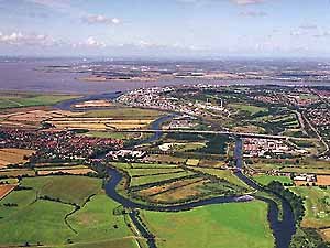
Marple marks a major intersection of the Upper and Lower Peak
Forest Canals with the Macclesfield Canal and has an important
British Waterways Depot Yard on the junction, with a nearby flight
of 16 picturesque locks leading down to Portland Basin in Ashton-under-Lyne.
The village of Marple itself is in pleasant rural surroundings,
despite its proximity to Stockport. Located alongside the Peak
Forest Canal within the beautiful Goyt Valley running through
it and overlooked by the Peak District National Park.
In the 1790s, Samuel Oldknow came to the district and began the
industrialisation that was to transform the former rural district.
Oldknow established his Mill by the River Goyt, sank coal mines,
built houses for his workers and made roads. He was also instrumental
in the construction of the local canal systems. Today, Marple's
industrial and architectural legacy make it well worth a visit,
and as recent growth in residential housing shows, it has become
a much sought-after location to live in.
Middlewich
Middlewich
is one of Britain's chief salt-producing towns and has been so
since Roman times. Romans were paid in salt, and the district
therefore held a valuable commodity. Middlewich lay on a major
Roman road from the Mersey at Warrington to Derby. They named
the town "Salinae" (Latin = salt works).
Later, The Saxon invaders from Europe were quick to realise the
importance of the town and by the time of the Domesday Survey
in 1086 it was rated on account of its large salt deposits. Tudor
Middlewich was also known for for its cheese production. But salt
has always been its major economy - by 1822 it produced £1,500,000
and paid revenue tax in the region of £32,000 a year into
treasury coffers. In 1825, the salt duty was abolished.
By the late 18th century Middlewich had seen the arrival of the
canals, which became vital in transporting salt and cheese from
Middlewich and coal in from Staffordshire via the Trent &
Mersey Canal. Many of Middlewich's houses were built by the waterways
companies still survive alongside the towpaths, with adjacent
stables for the horses which pulled the narrowboats. Commercial
use of the canals declined after the Second World War with improved
road and rail transport systems being preferred. However, in recent
times, the canals have seen a renaissance in their fortunes as
pleasure cruising has caught on as a popular holiday activity,
and several boat hire companies have moved into the town to bring
the canal system alive again.
Mobberley
A township
and parish in the ancient Bucklow Hundred, which includes the
hamlets of Baguley Green, Barnes Brow, Burleyhurst, Gorsey Brow,
Knolls Green, Newton, part of Paddockhill, Saltersley, Tipping
Brow and Woodend. Mobberley Village was said to have been the
second largest parish in England, located about 16 miles from
Manchester city centre in the northern green belt of Cheshire
almost halfway between Macclesfield and Warrington.
The distinguished second world war RAF commander, George Leigh
Mallory, was born in Mobberley on 18 June 1886, the son of a local
vicar.
Mottram
Before the
Norman Invasion Mottram was the centre of a large Anglo-Saxon
estate. In 1066 it came into the ownership of William the Conqueror,
and by the Domesday Survey of 1086 it had become part of the lands
granted to the Earl of Chester. The old parish of Mottram included
eight districts - Mottram itself, as well as Godley, Hattersley,
Newton, Hollingworth, Tintwistle, Matley and Staley. Various derivations
for the place name exist, though the most likely explanation is
that it denotes an ancient meeting place (from the Saxon "moot"
meaning a meeting or parliament and "ham" indicating
a township or settlement).
In the Middle Ages, Mottram was a local religious centre and market
town and by the 18th century the manorial courthouse was situated
there
By the time of the Industrial Revolution in the late 18th century,
Mottram had well developed cotton-spinning industries in the locality
and by the early 19th century the district also specialised in
shoemaking and tailoring. It also lay on on the main stagecoach
route from Manchester to Sheffield and was thereby regarded as
an important stopover for victuals and rest.
In 1936 the Urban District of Longdendale came into being and
Mottram was incorporated, along with Broadbottom, Hollingworth
and parts of Hattersley and Matley. The celebrated artist L
S Lowry lived in Mottram from 1948 until his death
in 1976. The last vestiges of the Industrial Revolution and the
local textile industries have long since passed into memory, and
nowadays Mottram is a very popular residential area and its mills
have been converted into small industrial and commercial units.
Nantwich
Nantwich is
an ancient market town located on the River Weaver within the
Borough of Crewe and Nantwich in central Cheshire. It has a strong
sense of history and identity and has many beautifully preserved
houses from various periods, set around an original medieval street
pattern with many listed buildings of significant historical interest.
Nantwich has long been associated with salt, (one of the so-called
three "wiches" of Cheshire - Nantwich, Northwich and
Middlewich). It is also a main producer of Cheshire cheese, has
a long history of leather tanning, and contains many spectacular
black and white half timbered buildings.
The town has survived many disasters in its time - in the 11th
Century it was virtually laid waste by the Norman invaders; in
the 13th century it was attacked by the Welsh, and in 1583 it
was almost destroyed by a great fire. However, the town was rebuilt
with financial help from Queen Elizabeth I. It was also repeatedly
besieged during the English Civil Wars, when it was a strictly
Parliamentarian township. The famous Battle of Nantwich in 1643
is re-enacted annually on 'Holly Holy Day', commemorating the
town's liberation from Royalist forces when inhabitants reputedly
danced in the streets, and curiously, wore sprigs of holly in
their hat bands. In the main town square stands St Mary's Church,
a fine sandstone building, known locally as 'The Cathedral of
South Cheshire', and is thought to be one of the finest medieval
churches in Britain. Nantwich is also a major canal town, with the Shropshire Union
Canal passing through it on a high embankment with a superb Thomas
Telford Aqueduct carrying it on its way southwards to the Midlands.
Northwich
Northwich
is located at the virtual centre of the Cheshire Plain at the
confluence of the rivers Dane and Weaver. Contemporary
Northwich also comprises Great Budworth (the second largest parish
in England) and the parish of Davenham. Along
with Middlewich and Nantwich, (the so-called three "wiches"
of Cheshire), it been a centre for salt mining since Roman times.
Roman occupation began in the 1st century AD, when a wooden fort
was established in the area. Thereafter, historical records lay
silent for some 800 years - until the Norman Invasion.
In Norman times the Budworth district of Northwich belonged to
the priests of Norton Priory. The newly created manor of Northwich
was ceded by William I to the Earl of Chester, and it remained
so until the last died in 1237, when the lands passed to King
Henry III's son, Edward, thereafter becoming Royal Manors and
the heir apparent from this time becoming the Earl of Chester.
Although in the possession of the Prince of Wales for most of
its history Northwich was usually tenanted to other "noble"
Norman families, who levied local taxes.
During the Civil Wars, following the Royalist's defeat at the
Battle of Nantwich in 1643, Northwich became a Parliamentarian
stronghold.
Today, the black and white half-timbered buildings which dominate
the centre of Northwich still bear witness to its long history.
Also worth visiting is the Salt Museum on London Road in Northwich,
and the Lion Salt Works Museum, which can also be viewed from
the Trent
& Mersey Canal.
Poynton
A township
in Prestbury Parish, in the ancient Macclesfield Hundred, which
was combined with neighbouring Worth in 1880 to create Poynton
with Worth Civil Parish. Poynton includes the hamlets of Clumber,
Coppiceside, Hockley, Lowerpark, part of Midway, Newtown, Petre
Bank, Poynton Green and Woodside. Though the township is not mentioned
in the Domesday Book, it was almost certainly included in the
Manor of Adlington. In earlier times the township was known as
"Ponynton" and even "Ponyngton"
and was in the possession of the de Stokeport family before passing
in the 14th century to John de Warren, a knight at the time of
King Edward III. The Warren family held the estates for many years
until the early 19th century, when Sir George Warren, the last
of the male line, passed them on to his daughter, Viscountess
Bulkeley. From her it passed through several notable family ownerships,
including the Venables, and finally, the Vernons.
Poynton was in ancient times a predominantly agricultural area,
(much as it is today), but it also included forestry and farming
of wheat, oats and corn crops as part of its economy.
In the mid-18th century the silk industry was established in Macclesfield
and this increasingly provided spinning work for the local population
so that by 1812 records show that there were 14 spinners. Later,
however, coal mining was to have a profound effect on the local
economy. Records show that coal mining of a sort had been carried
out in Poynton since 1589, but had probably existed there long
before records began.
Poynton is now a thriving small town, a much sought after place
to live, midway between Stockport
and Macclesfield and in the pleasant Cheshire countryside. It
is still a largely farming community, bordering Lyme
Park and the Peak
District and alongside the picturesque Macclesfield
Canal.
Prestbury
Prestbury
is a pleasant, affluent township in Prestbury Parish, in the old
Macclesfield Hundred, situated on the River Bollin, and located
just a few miles on the northern boundary of Macclesfield town.
It includes the hamlets of Bradley Mount and part of Withinlee,
Butley was also a township in Prestbury Parish, and was combined
with Prestbury in 1936. Fallibroome was also added to Prestbury
in the same year.
Prestbury is a long and narrow parish stretching along the Bollin
Valley towards Wilmslow, and is surrounded by Cheshire dairy-farming
country. One of the township's oldest buildings dates back to
1448 - the Priest's House, now a bank, which is an ancient timber-framed..
Also of interest is the Reading Room, a building erected in 1720,
this is now housing a branch library, a bank, an estate agent's
and the Parish Council Chamber. Dominating the centre, however,
is the parish church of St Peter, with an original chapel building
of Norman times, largely rebuilt in the 13th century, and substantially
restored in 1879 by the notable architect Sir George Gilbert Scott.
See Local Village Website: www.prestburycheshire.com
Now in the
County of Cheshire. Runcorn has a
long history and is first recorded in documentation in 916 AD,
when Princess Aethelfreda, daughter of King Alfred the Great,
paid a visit to the town to inspect the new fortifications.
Later, in Norman times, as part of the Bucklow Hundred, the Earl
of Chester granted the Barony of Halton to Nigel, the Constable
of Chester, who soon built a castle to dominate the Mersey estuary.
By the 12th Century the castle on Halton Hill had been replaced
in stone.
A weekly market and two annual fairs had already come into being
during medieval times and there were two windmills in or about
the township.
The nearby priory of Norton Abbey (created in 1391) was dissolved
in 1536, as part of King Henry VIII's dissolution of the monasteries
following his establishment of the Reformation in England and
the severing of all ties with Rome. The Abbey buildings and lands
were sold to Sir Richard Brooke who converted them into a home
where he and his family were to live thereafter.
During the English Civil Wars Parliamentarian forces took the
castle, and then lost it again to the Royalists. Later, on recapturing,
they decided to demolish the building, and much of its stone was
used in the houses built later in Halton village. By 1656, Runcorn
was described as "a fair parish church".
Later, in the 19th century, the arrival of canals changed it into
a thriving industrialised township as did the building of the
Manchester Ship Canal.
In 1936 the civil parish boundary was extended to include the
whole of Weston and part of Halton, and again in 1967 to include
the remainder of Halton and parts of Aston, Daresbury, Dutton,
Moore, Norton, Preston Brook and Sutton civil parishes. Nowadays
it includes the hamlets of Higher Runcorn, Runcorn Heath, Stenhills
and Westfield.