Townships
and Districts of Tameside
The
borough of Tameside is made up of 9 towns and districts. They
include : Ashton-under-Lyne, Audenshaw, Denton, Droylsden, Dukinfield,
Hyde, Mossley, Mottram and Stalybridge.
Ashton-under-Lyne
Considerable
disagreements locally about the derivation of the name of Ashton.
The Ashton part is straightforward : "village or town surrounded
by Ash trees". But the "under-Lyne" part is most contentious.
It possibly refers to the old boundary line between Cheshire and
Lancashire which ran through the town. Another possibility is
the Forest of Lyme (Lyme Park) which once covered the area.
The "under-Lyne" was actually only attached to the town name in
the mid-19th century, to distinguish it from other surrounding
towns of that name (Ashton-in-Makerfield for example). In medieval
times, Ashton centred on the Parish Church of St Michael's which
was probably mentioned in the Domesday Book of 1086. It became
a parliamentary borough in 1832 and by 1847 it was a municipal
borough with its own elected council. Its modern growth dates
from around 1850, when its population reached 36,000, due in the
most part to a thriving and expanding cotton industry.
The town was militant in its support for improved work and living
conditions. Ashtonians were at Peterloo in 1819, and the town
had a reputation for strikes. Friedrich
Engels, said of Ashton in 1844: "It has a more satisfactory
appearance than that of most factory towns". It was quick
to improve living standards - by 1902 it had electric trams running
in the town, and a sewage works was opened. In the post-war era,
Ashton has seen a great deal of rebuilding and modernisation of
the town centre, and it is a pleasant market town.
Audenshaw
The
origin of Audenshaw is probably from a personal old English name
"Aldwine", who once owned the land. Evidence for the existence
of "Aldwine's Shaw" (a small copse or wood) dates from records
going back to the 12th century. Originally part of Ashton Parish,
it became a separate Urban District in 1894, when it was still
described as "a pleasant and beautiful hamlet (a village) lying
in a wooded glen ( a vale or small valley)".
It saw rapid development after 1732, with the opening of the Manchester
to Mottram Turnpike which ran through it, and the setting up of
a toll house in the village. During the 1870s and 1880s, many
of Audenshaw's old buildings were destroyed when three large reservoirs
were built by Manchester Corporation.
Audenshaw Reservoirs are still a local geographic feature of the
district.
Until the 19th century it was still a farming area, with a few
local industries like Hatting, Bleaching a Coal Mining. Aston
Moss Colliery was once the deepest in Britain until its closure
in 1968. Robertson's Jams and Marmalades began production in their
Audenshaw factory in 1891, and the Jones Sewing Machine Company
was founded at Guide Bridge in 1859. Their new factory still stands
opposite the site of the original sewing machine works. Modern
Audenshaw has a major light industrial development at the Shepley
Industrial Estate, known locally as "Little Trafford Park".
Denton
Two
possible explanations are given for the origin of the name Denton.
One has it that it meant "Dane Town", a reference to the original
Nordic setters of the Tameside region, and another prefers "valley
settlement" from "den" meaning valley and "ton" meaning town or
settlement.
The town remained little more than a large village until the 19th
century, when the population expanded dramatically as it became
an incorporated suburb of Manchester. One of Denton's most remarkable
buildings is St Lawrence's Church, (above right), built in 1530
and known as Denton Old Church or "Old Peg" due to its timber
construction jointed with wooded pegs, typical of Tudor building.
Coal mining has existed in Denton for more than 200 years, and
it was at one time the town's most important industry. Hatting
was its second industry, dating back to the 16th century and a
flourishing local wool trade which provided the town with its
raw materials. The Denton Feltmakers Company Charter dates from
1604. By 1825 Denton had 20 hatting firms. Its decline dates from
the 1920s, though some hats are still made in the town.
Droylsden
Dating
from the 7th century, Droylsden's origins are somewhat obscure.
First mention of its name appears in the 12th century when it
was called "Drygel's Valley" - "dryge" being old English
for "dry", and "den" referring to a small valley, the whole name
probably means Dry valley. The Lord of the Manor was at one time
the famous poet Lord Byron, whose family were the hereditary owners
of the land on which the town stands. Droylsden's most notable
buildings include the Fairfield Moravian Settlement, which was
established in 1783, and occupies some 54 acres. A small religious
community, the Moravians lived separate and isolated lives, centred
around the Sunday School and the several other schools which they
established in the region.
Dukinfield
The
name Dukinfield means literally "ducks open land", hence "ducks
in a field" - Dukinfield. The ancient Lords of the Manor were
Duckenfield Family, and it once lay in the parish of Stockport.
In the 16th century it was, with Ashton, the chief township east
of Manchester. By the early 19th century, Dukinfield was predominantly
agricultural land, and supplied Manchester with most of its fruit
and vegetables. Later in the century, coal mining became its principal
industry. It thrived on the demand for coal to power steam engines
in local cotton mills.
The rapid expansion of industry in the late 18th century resulted
in the hitherto largely rural landscape being turned into an industrial
wasteland. Working conditions in the town were the worst in the
north west, and in 1837 the Dukinfield and Ashton-under-Lyne Poor
Law Union was created to help relief the plight of the working
poor or the region.
By the beginning of the 20th century most of Dukinfield's mines
were paid out, or else demand for coal declined, and the Dewsnap
and Astley Deep Pits were closed down. In time these were replaced
by light industries and engineering, which remain its primary
local industries.
Hyde
The
name derives from "hide", and old English land measure,
(used in the Domesday Survey of 1086), and roughly equivalent
to 120 acres. The town is largely a creation of the Industrial
Revolution, -previously it was little more than a single row of
cottages, known as "Red Pump Street", and part of the Parish of
Stockport. The present name only dates from the 1830s.
Hyde became a mill town, with the factory of the Sidebothams dominating
its economy with ownership of mills and coal mines. Its growth
was considerably enhanced by the opening of the Peak Forest Canal
in 1800.
The town was a stronghold of the Chartist Movement and its people
figured largely in the Peterloo Massacre of 1819. The Ashton family
were the earliest cotton pioneers in Hyde. From 1800, their family
businesses in coal and cotton made them powerful and wealthy figures
in Hyde, and their calico printing works at Newton Bank was a
major local employer. Thomas Ashton Jnr. was also a prominent
local Liberal politician, as well as being a determined industrialist
who was much respected by his workers.
During the so-called "Cotton Famine" of 1861-65, he kept his mills
running and refused to lay workers off, an act which earned him
an honoured place amongst local benefactors. More recently, Hyde
has seen considerable housing development, modernisation and growth,
and is a sought after residential area. A local distinction is
the renowned Hyde Seal Water Polo Team, who from 1904-1914 were
three times world champions.
Mossley
The
name "Mossley" has two elements - "moss" meaning "bog"
or "swamp" and the old English word "lea" or "leah"
indicating a clearing in a wood. In 1309, according to records,
the land was owned by Henry, son of William de Mossley, although
by the 19th century, it was little more than a small hamlet included
in the Manor of Ashton.
The town was once situated in three counties - Yorkshire, Lancashire
and Cheshire - and its three Parish Churches (St George's, Lancashire;
St John the Baptist, Yorkshire; All Saints, Cheshire), still mark
this partition. Its pre-Industrial Revolution industries were
farming and woollen cloth manufacture.
1765 saw the building of Andrew Mill on the River Tame, with other
mills following soon after. The abundance of free-flowing water
saw steam power very slow to catch on. Most mills were owned by
the Mayall Brothers. Gradually, the building of new roads and
the railway in 1849 saw its fortunes blossom.
By 1913 the cotton trade had reached its peak, with a million
and a half spindles and 600 mechanised looms working at any time.
The cotton trade began to decline from the 1920s, and over half
of its workforce were unemployed so that Soup Kitchens had to
be set up in the town to relieve the most dire poverty which this
promoted.
Since the Second World War, many new light industries have been
introduced into the town, though its population has continued
to decline throughout the 20th century, and residents mainly work
outside in neighbouring towns.
Mottram
Now
a part of the Longendale district which also includes Godley,
Hattersley, Newton, Hollingworth, Tintwistle, Matley and Staley.
The name Mottram derives from the old English word "moot"
- a meeting place or a council. A predominantly outlying rural
district, in 1800 the whole region had a population of only around
100, and Mottram was its main market town.
In the early 19th century Mottram was a district centre for shoemaking
and tailoring. It lay strategically on the main Manchester to
Sheffield Coach route, and was a major servicing stop for this
mode of transport. The flying coach, "the Umpire", as well as
trans-Pennine packhorse trains, all stopped at Mottram's Pack
Horse Inn.
Since 1936, Mottram was part of the Urban District of Longendale,
and became part of the Metropolitan Borough of Tameside after
boundary changes and local government reorganisation in 1974.
Mottram also has the distinction of having had the artist L.S.
Lowry living at "The Elms" on Stalybridge Road in the
town from 1948 until his death in 1976.
Nowadays, Mottram is a popular residential area. The mills have
gone or been converted to light industrial units, and textiles
is no longer the main employer of its people. Mottram still retains
many of its ancient customs, which draw large crowds to observe
their performance in summertime : they include the quaint customs
of bell change-ringing, rush carts and Morris dancing.
Stalybridge
The
name Stalybridge comes from the old English word "staef" (
a staff or stave) and "leah", a clearing in a wood. The
full meaning of "Staly" is therefore "a wood where staves are
collected". The "bridge" part was added in the 19th century, when
the town became an important market crossing point on the River
Tame.
In earlier days, Stalybridge was sparsely populated, and for the
most part made up of farmers and cottage weavers.
By 1750 there were already several mills along the Tame, powered
by the plentiful supply of clean water. When Edward Hall installed
the first steam engine in his mill in 1796, it was the signal
for the building of many steam driven mills in the town, and it
was at one time dominated by innumerable such smoke stacks - at
that time Stalybridge's most predominant feature.
The impact of industrialisation saw the population rise from about
140 in 1750 to 20,760 by 1850! Its prosperity brought many civic
benefits : the Police Force and Market in 1828, the Stalybridge
Gas Company in 1831 which brought street lighting to the town,
and a new Town Hall, also in 1831.
The mill workers of Stalybridge led the march to Peterloo in 1819,
and in 1817 an association later known as the "Blanketeers" (on
account of the sleeping blankets they carried slewn over their
backs) set out to walk to London to protest against poor working
conditions.
Political riots and strikes were prevalent in the town, which
supported the Chartist Movement. This civil unrest was probably
responsible for the setting up of the Stalybridge Police Force
in 1827, two years before the establishment of the Metropolitan
Police Force by Sir
Robert Peel, who is attributed with their invention.
Despite the Cotton Famine of the 1860s, conditions gradually improved
in the town, with the opening of the Mechanic's Institute in 1825,
the first public park opened by Lord Stamford in 1873, and the
Public Library in 1889. In the 20th century, Stalybridge has seen
many changes. Most of its mills were closed by the late 1930s.
New housing estates replaced the slums, and new light industries
were encouraged by the Industrial Development Committee set up
in 1934.
Today the town manufactures rubber goods, plastics, chemicals,
packaging materials and synthetic fibres. It is still a major
market town, and is a sought after place to live, lying as it
does within reach of the Greater Manchester conurbation and the
splendours of open countryside.
-
-
-
Tameside
Blue Plaques
(Information kindly supplied by Roy Parkes, Blue Badge Tourist
Guide, roy.parkes1@ntlworld.com)
|
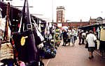
Ashton Market
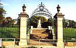
Memorial Gardens,
Ashton

St Lawrence's
Church, Denton
|

