Manchester,
Tameside & the Northwest of England
Papillon
Graphics' Virtual Encyclopaedia of Greater Manchester
Including
Bolton, Bury, Manchester, Oldham, Rochdale, Salford, Stockport, Tameside,
Trafford & Wigan
NAVIGATION Virtual
Hosting by
TheServerBank
Photos
by John Moss
The
Borough of Tameside
In the Greater Manchester Metropolitan County
Ashton Town Hall
- Tameside's
administrative centre
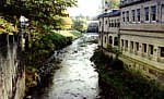
Tameside is,
as its title suggests, named after the River Tame and the Tame
Valley which diagonally cuts through the Metropolitan Borough.
Lying seven miles due east of Manchester, in the North West region
of England, it is a compact borough set in an area of great scenic
beauty, with significant industrial heritage and easy communication
with the rest of the country.
Tameside is
about eight miles across - with just under a quarter of a million
people living in its 50 square miles. It is bordered on the north
by the River Medlock, in the south by the River Etherow and the
scenically beautiful Werneth Low, to the east by the Pennines,
and to the west by the City of Manchester itself.
Unlike most
of the other Metropolitan Boroughs, it is not named after a town
or a city (such as are Rochdale, Oldham, Wigan, Bolton, Bury,
Stockport, Manchester and Salford), but came into being as a newly
created authority in the early 1970s after boundary changes were
instigated by central government, (as did the Metropolitan Borough
of Trafford). The Borough has its administrative centre in the
town of Ashton-under-Lyne.
History
of Tameside
In
47 AD, when the Romans reached the Fosse line, the kingdom of
Brigantia came under Roman rule, and suffered strict and oppressive
measures after the Brigantian revolt of 68 AD. Tameside featured
on the road which the Romans built from Manchester to Leeds
and a branch to the fort at Melandra ran through the northern
part of Mossley, within the present Borough.
After
Roman withdrawal from Britain in 410 AD, various petty invasions
and squabbles between local warlords took place, and by the
7th century Anglian immigrants had moved into the region and
occupied the land.
Most
of the place names of Tameside reflect this influence. The River
Tame itself (probably Norse meaning "dark river"), and other
places such as Werneth Low ("a place growing alder trees") as
well as Ashton and Denton (the Scandinavian word "ton" indicates
a town or settlement) - all show clear Anglian-Continental sources.
Oddly,
there seems to be little evidence of native British place naming
within the borough, suggesting that the Anglian invaders were
its first inhabitants and it had been hitherto unoccupied woodlands.
By
the time of the Norman Conquest of Britain in 1066, town and
village names had begun to be formalised and to appear in documents
of the time.
In
an entry from the Cheshire Domesday of 1086 the land was in
the possession of Hugh d'Avranches, earl of Chester - his possessions
were listed as also including Romily, Tintwistle and Werneth.
Though
Ashton is now the main town of Tameside, it hardly existed as
an entity in medieval times, though in 1413 a Market Charter
was granted to Sir John Assheton (after whom the town would
be named) to be held close to the church of St Mary and the
church of St Michael (the latter being St Michael's in Ashton).
The market was held every Monday at the junction of Old Street
and Cricket's Lane, where the town cross stood. The Charter
also granted a twice annual fair to be held in July and November.
The
markets were busy affairs as by the second half of the 16th
century Tameside had established a profitable local industry
in the production of mixtures of cotton and flax cloth. Later
it was to turn over entirely to woven cottons.
During the Tudor period there is extensive evidence of a thriving
textile industry, which including woollens, due, no doubt, to
the excellent sheep grazing pastures on the moorlands to the
east towards Saddleworth. Huge flocks of sheep were imported
from Ireland to develop the industry - at that time it would
still have been a cottage industry with production solely dependant
upon hand looms.
During
the Civil Wars, local Puritanism was very strong, and not surprisingly,
most of the towns of Tameside had Parliamentarian sympathies.
Robert Duckenfield (1619-1689) served alongside Sir William
Brereton in the defence of Manchester in September 1642 and
took part in the siege of Wythenshawe Hall, the seat of the
Royalist family of the Tattons.
The
Arms of Tameside
Heraldic
Description
Shield : "Per Bend Or and Vert a Bend barry wavy Argent and
Azure between in chief a Rose Gules barbed and seeded proper
and in a base a Garb Or." Crest : " Out of a Mural Crown Gules
a demi Lion guardant Or resting the sinister forepaw on an Escutcheon
of the Arms. Mantled Gules doubled Or." Supporters : " On the
dexter a Lion Or gorged with a Chain pendant therefrom a Mullet
pierced Sable and on the sinister a male Griffon Gules armed
beaked irradiated and gorged with a Chain pendant therefrom
a Cogwheel Or". Motto : "Industry and Integrity".
Explanation
of the Arms
The lower half of the shield depicts the gold (or) wheatsheaf
emblem of Cheshire on a green (vert) background. This is separated
by a blue (azure) and white (argent) band representing the River
Tame from the upper half of the shield which contains the red
(gules) rose of Lancashire on a gold (or) background. The crest
above the shield has been drawn from the fundamental elements
of the Arms of Greater Manchester County. The left hand (sinister)
supporter is a gold lion with a black (sable) pierced star (a
mullet) hanging from a chain around its neck. The right hand
supporter is a red griffin, used to depict dynamism and progress,
and hanging from a chain around its neck is a gold cogwheel
indicating the industrial aspects of Tameside.