|

|
Manchester
& the Northwest Region of England
 

Papillon
Graphics' Virtual Encyclopaedia of Greater Manchester
Including
Bolton, Bury, Manchester, Oldham, Rochdale, Salford, Stockport, Tameside,
Trafford & Wigan
|
|
NAVIGATION


Virtual
Hosting by

TheServerBank
|
 |
 |
The
Town & Borough of Bury
In the Greater Manchester Metropolitan County
|
The
Districts of Bury
Radcliffe
Radcliffe
is located in a semi-rural setting framed by the West Pennine
Moors and was originally a coal and cotton district - it takes
its name from 'red cliff' (rock) on the River Irwell. Its many
ancient buildings include the Parish Church, a Tithe barn and
Radcliffe Tower. It is the most westerly of Bury districts and
has a regular old market, a small shopping centred and is served
by the Metrolink Rapid Tram/Railway Station.
Ramsbottom
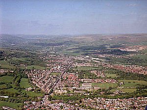
Aerial Photograph
of Ramsbottom
Image courtesy of www.webbaviation.co.uk.
Copyright © 2005
CLICK
ON IMAGE TO ENLARGE
Located
at the extreme north of the Metropolitan Borough of Bury in
the Irwell Valley lies Ramsbottom. This sleepy village almost
tucked away in the hills and valleys of Rossendale, has seen
considerable rebirth since the reopening of the East Lancashire
Railway and has become a popular and much sought after place
to live out of town. It boasts some of the most attractive countryside
in the borough and is a popular place to visit. Within the Ramsbottom
district are several other pretty villages, including Summerseat,
with its conservation area and the beautiful Irwell Gorge. The
name probably/possibly derives from the old English "Ramsons
Bottom". In former times the village was sometimes known
locally as "Tupp's Arse" ("tupp" being an
old regional word for a sheep or ram), though the name actually
has nothing to do with sheep or bottoms, but probably meant
"the valley of wild garlic" (or "ramson"
as the wild garlic is often called).
Edenfield
The
small village of Edenfield used to sit on the main A56 trunk
road, until it was by-passed by the M66 motorway. The area is
sometimes referred to as Tottington Higher End. In the 19th
century Edenfield, Ramsbottom, and Tottington grew increasingly
popular with the middle classes eager to move out of the industrialised
town centre into more pleasant and rural settings - this still
tends to be true of these districts.
Tottington
Tottington
once included part of what is now Ramsbottom, and as open farmland
has long been regarded good hunting land where traditionally
deer and wild boar were hunted. This quiet little backwater
saw the resident population increase considerably during the
early 19th century. Tottington, or "Totty" as it is
known locally has a local Heritage Society which publishes a
number of useful booklets on surrounding areas, including Tottington,
Shuttleworth, Summerseat, Cheesden and Birtle.
Whitefield
Whitefield
is a predominantly residential community, much favoured by the
Jewish community who have a large settlement in the district.
The district's proximity to the M60 Orbital Motorway and City
of Manchester has ensured that there are many flourishing industries
as well as retail parks located locally.
There are at least two theories for the origin of the placename.
One is that the name comes from the Flemish weavers who used
to lay out their fabrics to bleach in the sun; the other relies
on the fact that historically Whitefield has been a farming
community of open fields and that the name is a corruption of
"Wheatfields. The village is dominated by the splendid
Stand Church, (All Saints CofE Church), which was a so-called
'Waterloo Church' fund, having been built to celebrate Napoleon's
defeat at Waterloo. The old district of Stand is also located
in Whitefield, and used to be evidenced not only by All Saints,
but by Stand Grammar School for Boys (now demolished), Stand
Girls Grammar School (now Philips High School), Stand Cricket
Club and Stand Lane.
Prestwich
Prestwich
comes from the Saxon meaning "a Priest's retreat"
- a pub in the village has recently adopted this as its new
name. It is situated about 3½ miles north of Manchester
City centre and 4 miles south of Bury centre. In earlier times
the district was predominantly farmland, but the area grew considerably
during the Industrial Revolution. Along with Whitefield it boasts
the second largest Jewish community in the United Kingdom. It
is located immediately south and adjacent to the M60 Outer Ring
Road, with access to the entire northwest motorway network.
Nowadays the village shopping centre is busy and popular, with
a profusion of local specialist shops and major supermarkets.
Lying as it does on the main A56 trunk road northwards, midway
between Manchester and Bury, and with a local Metrolink Railway
Station it is an accessible and convenient shopping venue.
Just to the north of Prestwich lies Besses O' Th' Barn. This
oddly named area, known locally simply as "Besses",
is actually an old industrial town whose name has potentially
colourful origins. One improbable explanation of the placename
involves the highwayman Dick Turpin's famous horse, Black Bess.
But, in all probability the name derives from one its most infamous
pub landladies. Besses is probably best known for its celebrated
brass band, multiple prize and championship winners, one of
the oldest surviving brass band ensembles in the world.
See
Also:
|
|