|
NAVIGATION


Virtual
Hosting by

TheServerBank
|
 |
 |
The
Borough of Trafford
In the Greater Manchester Metropolitan County
|
The Districts of Trafford
Ten
local towns and districts were joined to make the Metropolitan
Borough of Trafford. They are : Altrincham, Bowden, Carrington,
Dunham Massey, Hale, Partington, Sale, Stretford, Urmston and
Warburton.
While
all 10 districts have a common bond in the borough, each has its
own individual and often ancient character.
Altrincham
(Pronounced:
Alt-ring-ham and not Alt-rinch-ham). With a population
of over 40,000, Altrincham is Trafford's charter town, and still
retains its distinctive sense of being predominantly a market
town, which still operates and thrives today on Tuesdays, Fridays
and Saturdays.
The
original Old Market Place was the home of the stocks and whipping
post and is still surrounded by some of Altrincham's oldest and
most prized buildings.
The
town originally included Dunham Massey and Carrington, and was
granted full Municipal Borough status by King George VI in July
1937.
The
Industrial Revolution came to the town in the 18th century and
during this time the town's principal industry was cotton and
worsted manufacturing, which survived until the 1840s. It's memory
is retained in local placenames such as Mill Street (off Grosvenor
Road), and the Old Mill pub near the former Altrincham railway
crossing was.
|
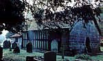
St Werburgh's
Church, Warburton
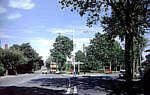 Stretford

Goose Green,
Altrincham
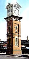
The Station Clock,
Altrincham
|
Cotton
was delivered in bales by canal for the Altrincham and Styal
mills after 1766 when the canal came. The Old Mill had been
powered by a spring from Old Market Place, was rebuilt in 1780
with steam added in 1785 but in the 1840s it was converted to
a hotel.
The
town is now a terminus for the Metrolink Tram System which connects
it directly with Manchester City centre. Altrincham has now
returned to its former status as the principal market town on
the edge of the Borough of Trafford.
Bowden
Population:
5,190. An attractive and almost entirely residential small country
town set in the midst of open countryside. Much sought after
properties. A 19th century scribe described Bowden as "a beautiful
rural village, exceptionally pleasant, even for England". The
name is derived from 2 Saxon words "bode" (a dwelling),
and "don" or "dun" indicating a plain on a rise
or down, on account of the sandstone edge on which it stands.
The parish church of St Mary's dates back before Norman times.
Carrington
With
a recorded population of just under 400 and an area of 2,00
acres, Carrington is the smallest district within the borough.
The lands were the property of the Earls of Stamford until relatively
modern times, when huge tracts were purchased by Manchester
Corporation and others by the Shell UK Corporation, who have
constructed a large refinery here, as well as the Carrington
Business Park. As a result, the resident population is small,
though the area provides employment for many thousands of workers
who travel into it every day.
The
Business Park is a welcome home to many new businesses, and
many small units, offices, studios and services have been provided
to encourage new business to move into the park.
Dunham
Massey
Population:
460. This is Trafford's main Stately Home, and most of its area
is open deer park and parkland. The 18th century house is set
in 230 acres of park. For over 300 years it was the seat of
the Earls of Stamford and Warrington. See main entry : Dunham
Massey.
Hale
Hale
is a relatively small district, like Bowdon, and similarly is
a much sought-after residential district, with spacious tree-lined
roads, pleasant shopping facilities, parks, open spaces and
other amenities. Its population is just over 16,000 and it covers
2,264 acres. From entries in the Domesday Book it seems to have
once been primarily forested land with a small settlement in
a clearing. It still retains much of its rural character and
natural beauty.
Partington
The
former Parish of Partington on the east bank of the Manchester
Ship Canal, has old historical ties, since in the 10th century
the Danish leader Cythric Silkybeard led an army into battle
along the River Mersey in the area. According to the Anglo-Saxon
Chronicle, his men slew 20 Partington men.
For
many years a farming community, its modern development dates
from 1871 when the watermill became the centre of a local paper-making
industry. In the 20th century, this little village was transformed
into a major township with increasing population and housing
development.
Today
it has a twice-weekly market, good shopping facilities, a health
centre, library, leisure centre, swimming pool and community
centre.
Sale
Prior
to municipal reorganisation in the early 1970s, Sale included
Ashton-on-Mersey and Sale Moor, and was the second largest Municipal
Borough in Cheshire.
In earlier days it was an Anglo-Saxon farming area. Its modern
development came with the building of the railway line from
Manchester to Altrincham in 1849, and it still benefits from
this connection. It is now a sought after residential area.
Stretford
Its
Roman origins are borne out by the name, derived from "streta",
meaning a paved road, and "Ford", a river crossing place. It
was here that the Roman road crossed the River Mersey. It is
now the administrative headquarters of Trafford Metropolitan
Borough Council, located in Trafford Town Hall in Talbot Road.
By
the 14th century, Stretford had become a major wool producing
and manufacturing area. Its modern development can be attributed
to the building of the Bridgewater Canal through the borough
in 1761 and later, the Manchester Ship Canal which connected
it to the Trafford Park area. Now a thriving modern borough,
its large shopping complex, the Arndale Centre with over 200
retail outlets, makes it a popular shopping area with residents.
Urmston
A
former Lancashire Urban District, Urmston included Flixton and
Davyhulme, and is the largest township in the Borough of Trafford.
Its name derives from an early owner - Orme Fitz-Seward, and
the Saxon "ton" meaning town or dwelling - hence "Orme's
ton".
Later the land passed to Richard de Trafford. One of its major
modern landmarks is the Barton High Level Bridge which carries
the M60 Orbital Motorway over the Ship Canal. Urmston is a busy
shopping centre, with excellent local shops and an outdoor market
held three days a week. Other amenities include a new leisure
centre and swimming pool.
Warburton
The
small parish of Warburton dates from Saxon times as "Wareburghtune",
named after the ancient St Werburgh's Church, rebuilt in the
12th century with later Tudor and Jacobean additions (top right).
Around
1190, Norbertine White Canons from Normandy were given land
in Warburton where they founded an abbey (the area now known
as Abbey Croft).
It
was at Warburton that a Toll Bridge was built over the Ship
Canal, to accompany the original one that crossed the River
Mersey at this point. Warburton retains much of this historic
atmosphere, as well as many of its half-timbered houses and
old farm buildings, which have been carefully preserved among
the more recent residential developments which have taken place.
See
also: Trafford Hotels
|
|
