Manchester
& the Northwest Region of England
Papillon
Graphics' Virtual Encyclopaedia of Greater Manchester
Including
Bolton, Bury, Manchester, Oldham, Rochdale, Salford, Stockport, Tameside,
Trafford & Wigan
NAVIGATION
Virtual
Hosting by
TheServerBank
History
& Heritage
in and around Greater Manchester
Early
Manchester
From
the Roman Fort at Mamuciam AD 70 to the Norman Conquest of 1066
When
General Julius Agricola, (40 - 93 AD), the commander of the invading
Roman legions, arrived at a sandstone bluff overlooking the confluence
of the Rivers Irwell and Medlock on a major roadway from the Roman
settlement at Deva (Chester) to Eboracum (York), he saw instantly
that it was, potentially, an excellently defensible position against
the native Celtic tribe, the Brigantes, (perhaps where the word
"brigand" comes from), who were (to put it mildly) less
than pleased by the uninvited occupying force's arrival in their
ancestral territories.
Agricola immediately set about building a wooden fortress. He
called the place "Mamuciam" (ssosmetimes spelt
'Mamucium' - meaning "a breast shaped hill")
because of the then distinctive shape of the outcrop. The site
of this encampment is marked today by Camp Street (actually in
Salford).
Agricola's
original fort covered some 5 acres and was then surrounded by
woods where deer and wild boar were still to be found. Eventually,
the Brigantes were won over and even Cartimandua, their queen,
was to become a firm friend of Agricola.
The original garrison was probably populated by legionaries from
Spain and Romania, and it must have seemed a very dark, cold and
damp outpost at the very edge of the Roman Empire in comparison
to the sunny climes of their native lands. An inscription on the
reconstructed North Gate of the present Fort, (as it would have
appeared around 200 AD), commemorates troops from the provinces
of Rhaetia and Noricum (roughly approximating to modern Austria),
and their centurion is identified as Lucius Senecianius Martius.
Over the next 3 centuries, a stone fort was built further downstream
at what was to become Castlefield (simply known by medieval times
as the "castle in the field"), and the inevitable small
encampment (or vicus - a place to live) grew around it
- at its height it is estimated that some 2000 people lived within
its walls, including soldier's wives and families together with
craftsmen and traders. Many of these would have been Britons who
eventually intermarried with Roman legionaries. This was the origin
of Manchester, and the people became the Romano-British.
The later stone fort was built at the present day site, where
the 1970 excavations and reconstruction is visible, and well worth
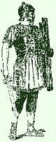
a visit. In summer, two tour guides dressed as Roman legionaries,
conduct guided tours around the fortress.
A Roman exhibition can also be seen in the nearby Castlefield
Visitors' Centre. Many valuable archaeological finds exist, including
fragments of Spanish pottery and a word square bearing the words
"Pater Noster" (Latin = "Our Father" - the
beginning of the Lord's Prayer) - these two are dated at between
170-175 AD, the oldest known Christian relics in Great Britain.
n
Monument to Agricola
on Manchester Town Hall and one of the Castlefield markers.
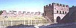
The reconstruction
of the North Gate of the final stone fort at Castlefield, off Liverpool
Road
Roman Legionaire
The Castlefield Canal Basin - "Castle in the Field"
Books
about Roman Manchester
Books
about Saxon England
The
reconstructed North Gate has been built on the excavated foundations
of the original fort, using evidence from other Manchester excavations
as a guide. It shows how the gate would have appeared around
200 AD This position is flanked by the two original defensive
ditches which were built during the 3rd century AD. Above the
arch in the gate is a guardroom, furnished with reproduction
furniture in the style of the period. An inscription on the
gate commemorates a detachment of troops from the provinces
of Rhaetia and Noricum (modern Austria) and their centurion,
Lucius Senecianus Martius.
At
its height, the fort and the spreading civilian settlement around
it probably amounted to about 2000 people. The fort was abandoned
in 411 AD, marking the complete withdrawal of Roman troops from
Britain, and the township (the vicus) probably fell gradually
into disuse. Over time the purpose of the ruined fortress was
lost in obscurity, and "the castle in the field" suffered
as did most other ruins, as a useful place for locals to acquire
(steal) ready dressed stones to repair their houses and barns.
Saxons, Norsemen and Danes in Manchester
The
Roman withdrawal from Britain in the 5th century AD left the town
open to the ravages of further European and Scandinavian invasions,
notably the Saxons, who renamed the township "Manigceastre".
These fierce Northmen attacked and plundered the town in 429 AD.
Later,
Edwin, King of Northumbria, conquered and occupied the town in
620 AD.
In
870 AD the Danes invaded and virtually razed the town to the ground
in a prolonged and bloody conflict. So bloody was the conflict
that, the southern district of Reddish (now part of Stockport)
is thought to have derived from the blood red field of battle.
The rebuilt "Danish" town's early streets were named
by them. The Danish word "gat" (meaning "road")
is still evidenced in Deansgate and Millgate. Danish invaders
had arrived by longboat by sailing up the River Mersey, unopposed,
as far as Warrington.
By
923 AD, the town, now commonly known first as "Mamecaestre"
and then as "Manceastre", came under the rule
of West Saxon kings, and became a garrison for the troops of Prince
Edward the Elder. An effigy of their patron saint, the Archangel
Michael, is thought to have been brought with them, and the so-called
"Angel Stone" can still be viewed in Manchester
Cathedral. At that time, the Cathedral would have been known
as the Church of St Mary, and is briefly mentioned in the Domesday
Book of 1086 AD. The Angel Stone was unearthed by workmen repairing
the South Porch in 1871, and is almost the only surviving relic
of Saxon times in Manchester
There
is a brief historic reference in the town records of Edward, son
of King Alfred the Great, taking over the town in that year and
making repairs to the "fortifications", (probably based around
the present cathedral), which would still have been little more
than a wooden palisade.
During
the 10th century, the church of St Mary was established at the
north end of Deansgate - that church is now Manchester Cathedral.
In
1028, King Canute regarded the town as important enough to found
one of his 10 royal mints here.
It
was during the Anglo Saxon period that Manchester, which had hitherto
been established around the Roman Fort at Castlefield was re-established
around the Cathedral, about a mile north of the old town.
The Normans in Manchester
After
the Norman Invasion of 1066, William of Normandy carved his newly
won lands into sizeable portions to give out as rewards to the
barons who had loyally supported him in the Conquest of England.
They in turn, further divided the lands as gifts in payment to
their knights and soldiers. William gave the lands around Manchester
to Roger of Poitou, who in turn bestowed the Manor of Manchester
on Nigellus, a Norman knight. Nigellus subsequently gave the manor
as a present to his son-in-law, Albert de Gresley, whose son Thomas
was granted The Great Charter of Manchester in 1301, under which
it became a free borough. His successors were to create and found
the collegiate church which became Manchester Cathedral.
The
Trail around Roman Manchester
The
trail begins outside the White Lion pub on Liverpool Road, and
is organised by the Castlefield Management Company. The Trail
includes:
The
Roman Gardens
A selection of plants, herbs and trees thought to have been
introduced by the Romans;
The
Vicus
The civilian settlement outside the fort, mainly inhabited by
the wives and families of soldiers as well as neighbouring tribes
(the Brigantes);
The
North Gate
The reconstruction of the final fort built around 200 AD with
Commander's House, stables, hospital, barracks and granary;
Defensive
Ditches
In front of the North Gate the 3rd century earthworks which
formed the primary defence;
The
West Wall
A largely reconstructed wall overlooking the surrounding countryside.
For
more information on Castlefield and the Roman Fort, contact:
The
Castlefield Management Company Castlefield Centre, 101 Liverpool Road,
Castlefield, Manchester M3 4JN
Tel: 0161-834 4026. Fax: 0161-839 8747.
Registered Charity Number 1054182.


 n
n