Castlefield,
Manchester Plan & the Northwest Region of England
Papillon
Graphics' Virtual Encyclopaedia of Greater Manchester
Including
Bolton, Bury, Manchester, Oldham, Rochdale, Salford, Stockport, Tameside,
Trafford & Wigan
NAVIGATION
Virtual
Hosting by
TheServerBank
Maps
of Manchester -
Castlefield
Street
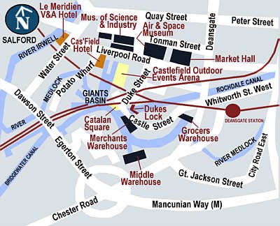
Map of Castlefield Basin
Showing
main tourist attractions, canals and railways, Castlefield Hotel,
the Museum of Science and Industry, the Air & Space Museum,
Catalan Square, Grocers, Merchants and Middle Warehouses, the
Rochdale and Bridgewater Canals and the Castlefield Outdoor Events
Arena.
Large Format Plan of Castlefield Basin , Manchester
Access a larger
street level detailed map of the Castlefield Basin and its immediate
environs by clickinghere.
(This is also a very large detailed map - please be patient and
wait for it to load completely).
Copyright
@ John Moss, Papillon (Manchester UK) Limited 2000-2008 AD Salford, Greater
Manchester, United Kingdom - all rights reserved. This page last updated
17 June 02.